Condado de Montgomery (Maryland)
Condados dos Estados Unidos | |||
[[Imagem: |275px|center]] |275px|center]] | |||
 | |||
Localização do Condado de Montgomery em Maryland | |||
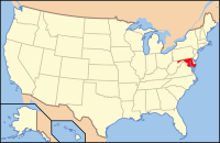 Localização de Maryland nos Estados Unidos | |||
Dados gerais | |||
| Estado | |||
| Sede | Rockville | ||
Área Metropolitana | Washington, D.C e Baltimore–Washington | ||
Data de fundação | 1776 (243 anos) | ||
Maior cidade | Rockville | ||
Cidades incorporadas | 22 | ||
Governo | |||
Executivo | Isiah Leggett[1] | ||
Presidente | Valerie Ervin | ||
Vice-Presidente | Roger Berliner | ||
Conselheiros[2] | Eleitos
| ||
Características geográficas | |||
| Área | 1 312,99[3]km² | ||
| - Área terra | 1 272,33 km² (96,90%) | ||
| - Área água | 40,66 km² (3,10%) | ||
População | 971 777[3](2010) | ||
Densidade | 763,78 hab/km² | ||
Código FIPS | 24031 | ||
| |||
Website: www.montgomerycountymd.gov/ | |||


O Condado de Montgomery (em inglês: Montgomery County) é um dos 23 condados do estado americano de Maryland. A sede e maior cidade do condado é Rockville. Foi fundado em 1776.
| ||||||||||||||||||||||||||||||||||||||||||||||||||||||||||||||||||||||||||||||||||||||||||||||||||||||||
O condado possui uma área de 1 313 km², dos quais 1 272 km² estão cobertos por terra e 41 km² por água, uma população de 971 777 habitantes, e uma densidade populacional de 763,8 hab/km² (segundo o censo nacional de 2010[3]). É o condado mais populoso de Maryland, e o 42º mais populoso dos Estados Unidos.
Ligações externas |
Sítio oficial (em inglês)
Referências
↑ «Office of the County Executive: Isiah Leggett». Montgomery County, Maryland. Consultado em 10 de julho de 2011
↑ «Montgomery County Council». Montgomery County, Maryland. Consultado em 10 de julho de 2011
↑ abcd «GCT-PH1 - Population, Housing Units, Area, and Density: 2010 - State -- County / County Equivalent» (em inglês). United States Census Bureau. Consultado em 13 de setembro de 2011
↑ «GCT-PH1-R - Population, Housing Units, Area, and Density (geographies ranked by total population): 2000 - Geography: State -- County - State -- County / County Equivalent» (em inglês). United States Census Bureau. Consultado em 15 de agosto de 2011
↑ «Censo histórico de todos os condados de Maryland (1900 a 1990)» (em inglês). United States Census Bureau. Consultado em 17 de junho de 2010


